
Land Surveying Is Playing a Larger Role in Floodplain and Elevation Planning
Flooding is one of the most common and costly risks facing landowners and communities today. As weather patterns shift and local rules grow more detailed, knowing exactly how high or low a piece of land sits becomes far more than a simple detail. Land surveying provides precise measurements that show the true shape and height of a site. This information helps everyone involved make choices that reduce risk, follow rules, and protect investments over time.
Why Precise Elevation Data Matters More Than Ever in Land Development Decisions
Every piece of land has a unique elevation profile. This means some areas sit higher and drier while others slope toward lower ground or natural water paths. In the past, developers often relied on general maps or rough estimates to plan projects. Today, stricter guidelines and a better understanding of flood behavior demand much more exact information.
Accurate elevation data guides almost every major decision. It tells you if a site is suitable for building, how much work will be needed to prepare the ground, and what limits apply to construction. When regulations change, these measurements become the main proof that a project meets safety and legal standards. Without them, you may face delays, extra costs, or even orders to change plans halfway through work.
Investing in proper surveying early gives you a clear picture of what is possible. It removes guesswork and lets you decide whether to move forward, adjust the design, or look for another location. This upfront clarity saves time and money in the long run.
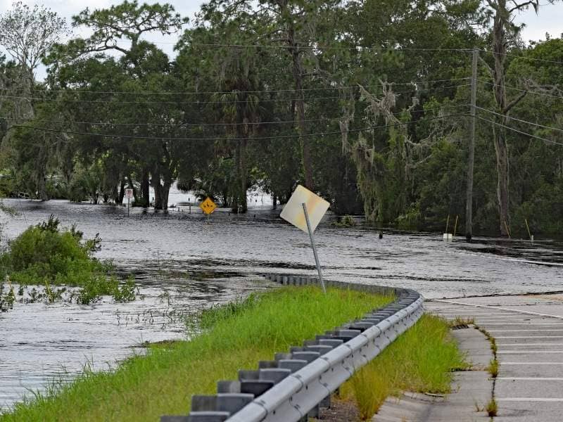
How Land Surveying Helps Interpret Floodplain Mapping More Accurately
Government agencies publish floodplain maps to show areas at risk of rising water. These maps are useful guides but they are often created using broad data that does not capture every small change in the land. On the ground, a property may sit slightly higher or lower than the map suggests. This difference can change whether a location counts as high risk or low risk.
Land surveying fills this gap by taking direct, on-site measurements. It records exact heights at key points across the lot. These measurements can be compared against official flood levels to see exactly where the land stands. This comparison helps you understand:
- How much higher the ground is above the expected flood level
- Which parts of the property slope toward water flow paths
- Where natural ridges or depressions may change how water moves during heavy rain
- Whether the mapped boundary matches the actual conditions on site
With this level of detail, you can trust the results more than you can rely on a general map alone. It reduces confusion and gives you solid facts to work with.
Supporting Risk Assessments for Residential and Commercial Properties
Before buying, building, or insuring a property, people want to know what risks they face. Flooding can damage buildings, destroy belongings, and lower property value. It can also make insurance harder to get or more expensive to maintain.
Land surveying provides the data needed to complete a full risk review. It shows how the site sits relative to nearby rivers, lakes, storm drains, and low-lying areas. Property owners and investors use this information to judge how likely water is to reach the land. They can also see how much protection the natural ground level already offers.
For homes, this data helps owners decide how to build or renovate to stay safe. For businesses, it helps protect inventory, equipment, and daily operations. Even lenders look at elevation details before approving loans, because lower ground carries higher risk. Clear measurements make it easier to understand exposure and plan for the future.
Providing Critical Data for Site Design and Infrastructure Planning
Designing a useful and safe space requires knowing how every part of the land relates to the next. Elevation measurements guide how roads, walkways, parking areas, and building locations are laid out. They help planners figure out how to keep access open and stable no matter what weather comes.
Engineers and designers use survey data to set proper slopes and heights. They decide where to place building entrances, where to run utility lines, and how to shape open areas. Even small differences in height can change how well a site functions. If one part sits too low, it may block access or cause problems with other parts of the project.
This information does not focus on how to drain water specifically, but it creates the base layout that works with natural ground movement. When all structures and paths align with the true elevation, the whole site works better and requires fewer fixes later.
Helping Property Owners Prepare for Future Regulatory Changes
Rules about flood risk and land use do not stay the same forever. As more information becomes available, agencies update flood maps, raise required building heights, or set new limits on what can be built in certain zones. What was allowed a few years ago may need extra proof or adjustments today.
Current and accurate land survey records act as a long-term reference. They show exactly what the land looked like at a specific point in time. If rules change later, you already have proof of the site’s natural conditions. This can help you show that existing structures or plans still fit within new guidelines.
Having this data ready also makes it easier to update permits or make improvements down the line. Instead of starting from scratch, you can compare new requirements to your existing measurements. This preparation reduces stress and keeps your options open as laws and conditions evolve.
Frequently Asked Questions
What role does land surveying play in floodplain planning?
It provides exact elevation readings and boundary details that show how a property relates to flood-prone areas. This information helps define risk levels, guide design choices, and meet government requirements.
Why is elevation data important when evaluating a property?
It tells you how high the land sits compared to nearby water sources and flood levels. This detail reveals how likely the site is to face flooding, which affects safety, insurance costs, building rules, and property value.
Can survey measurements help clarify floodplain map information?
Yes. Official maps use general data and may not reflect small changes on individual lots. Survey results give precise on-site readings that confirm or adjust what the map shows, giving a more accurate view of actual risk.
Who typically uses elevation data during project planning?
Developers, architects, engineers, insurance providers, lenders, and local planning offices all use this information. Each group relies on it to make safe, legal, and practical decisions about the land.
How can updated survey information support future property decisions?
It creates a permanent record of the site’s conditions. If flood maps or building rules change, this record helps you show compliance, adjust plans, or prove the property’s true status without needing to gather new data from scratch.